
Drone Studio NC • Raleigh, North Carolina
Drone Studio NC provides professional surveying and mapping drone services across Raleigh, the Triangle, and throughout North Carolina. We deliver the full range of aerial geospatial data your project needs, including high-accuracy orthomosaic maps, detailed topographic and contour surveys, photorealistic 3D terrain models, and precise volumetric calculations. Our FAA-certified pilots and professional mapping equipment give engineers, developers, contractors, farmers, and land managers the survey-grade data they need to plan, design, and execute projects with total confidence. Whether you are managing a construction site in Wake County, developing agricultural land across the NC Piedmont, or documenting a real estate property in the Triangle, our surveying and mapping drone services deliver faster results and greater cost efficiency than traditional ground-based methods. Each of our core deliverables is explained in full below. Looking for a different service? Explore our aerial photography and videography or drone inspection services for additional solutions.
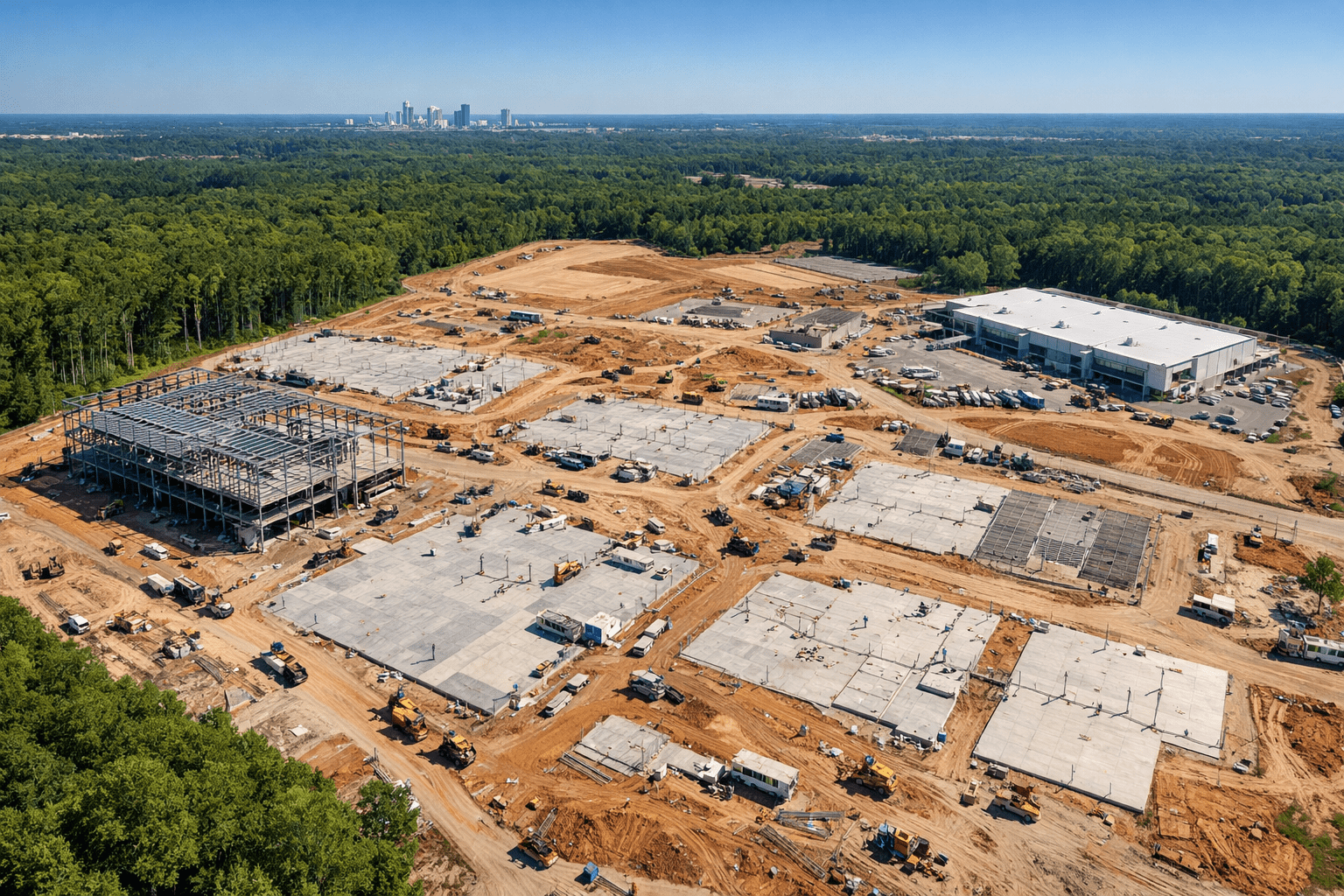
Drone surveying and mapping is the process of using unmanned aerial vehicles equipped with high-resolution cameras to capture detailed aerial imagery across a defined survey area. Unlike traditional ground-based surveying methods that require physical access to every point on a site, drone mapping systems collect hundreds of overlapping aerial photographs from a precisely controlled flight path. These images are processed to generate accurate orthomosaic maps, elevation models, contour lines, and volumetric calculations that meet the accuracy standards required for engineering, planning, and construction applications.
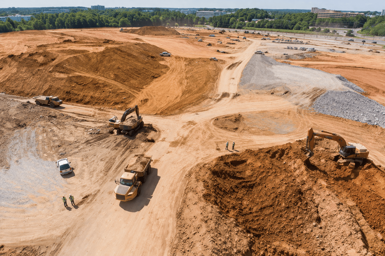
For construction developers, civil engineers, and contractors working across Wake County — from large mixed-use developments in Raleigh and Cary to residential subdivisions in Holly Springs, Apex, and Fuquay-Varina — drone surveying delivers site data that is faster to acquire, more comprehensive in coverage, and significantly more cost-effective than traditional ground crew methods. A site that would require a survey crew several days to map can typically be covered in a single morning flight session, with processed deliverables returned within 24 to 72 hours. For grading and earthwork contractors, our volumetric stockpile analysis eliminates manual pile measurements, providing accurate material volume calculations with verifiable aerial documentation.
Agricultural operators, land managers, and environmental consultants across Wake County rely on drone mapping for precision agriculture applications including crop health analysis, drainage assessment, and irrigation planning. Our surveys generate detailed aerial imagery that reveals field conditions invisible to ground observation. Real estate developers use our orthomosaic maps for site selection, boundary documentation, and regulatory submissions. Utility companies and government agencies use our 3D terrain models and contour surveys for infrastructure routing, floodplain analysis, and environmental impact assessments. Every project begins with detailed flight planning to determine the optimal flight altitude, image overlap, and ground control point network required to achieve your target accuracy specifications.
Construction developers and general contractors, civil and geotechnical engineers, land surveyors, agricultural farmers and operators, real estate developers, government and municipal agencies, utility and infrastructure companies, mining and aggregate operations, environmental and ecological consultants, and insurance and litigation support professionals across Wake County and North Carolina.
High-accuracy orthomosaic maps, aerial elevation models, topographic contour lines, volumetric stockpile calculations, aerial site overview images, and full project reports with flight logs. All deliverables are properly positioned to your site’s coordinate system and ready for use by your engineering or planning team.
Ground control point (GCP) based workflows achieve horizontal accuracy of 2 to 3 centimeters and vertical accuracy of 3 to 5 centimeters. All data is validated with independent check points and delivered with a full accuracy report meeting North Carolina Class A survey standards and accepted by engineering firms across Wake County.
We handle any project size from single residential lots under 1 acre to large-scale agricultural and infrastructure surveys covering 10,000+ acres across multiple flight days. Standard projects are completed flight-to-deliverables within 48 to 72 hours. Expedited 24-hour turnaround is available for time-critical projects. Recurring survey programs are available for construction sites requiring regular progress documentation and volumetric tracking.
GeoTIFF orthomosaic images (full resolution), DXF and DWG CAD-compatible files, KML/KMZ for Google Earth, PDF and PNG overview reports, CSV volumetric data, and Shapefile format for GIS platforms. Delivered via secure cloud download link. Custom formats available on request.
Drone surveys are completed up to 5x faster than traditional ground crew methods, reducing mobilization time and labor costs by 60 to 80 percent on typical site sizes. No physical ground access is required, making drone surveys ideal for active construction zones, hazardous terrain, steep slopes, and areas that are difficult for survey crews to access. Full aerial coverage gives you a complete picture of your site that ground-based methods simply cannot match.
02 Volumetric Measurements
Why Drone Studio NC for Surveying & Mapping
Engineers, developers, agricultural operators, and land managers across the Triangle trust Drone Studio NC because we deliver survey-grade geospatial data with the accuracy, consistency, and reliability their projects demand. Every surveying and mapping drone project is planned by experienced professionals, captured with high-resolution drone cameras and precisely placed ground control points, and processed so your data meets the highest accuracy standards. Our team of FAA Part 107 certified pilots understands the unique terrain, vegetation, and regulatory environment across North Carolina, from the flat coastal plains of eastern NC to the rolling Piedmont hills around Raleigh and the mountainous western regions. That local expertise means better flight planning, more accurate data capture, and deliverables tailored to how our NC clients actually work. Whether your project involves drone inspections, agricultural field mapping, construction site surveys, or real estate and insurance property documentation, we bring the same commitment to precision and professionalism to every engagement.
Receive your completed geospatial deliverables within 48 to 72 hours via secure cloud link. Every dataset is properly positioned to your preferred coordinate system, thoroughly quality-checked against ground control, and delivered in formats ready to import directly into AutoCAD, Civil 3D, ArcGIS, Trimble Business Center, and other design and analysis platforms your team already uses. Need additional drone services? Our aerial photography team can capture marketing visuals during the same site visit.
A curated selection of recent surveying and mapping drone projects completed for clients across Raleigh, Durham, Cary, Chapel Hill, and the greater Triangle area. Our portfolio features high-accuracy orthomosaic site maps for civil engineering firms, 3D terrain models for residential and commercial land developers, volumetric earthwork surveys for general contractors, topographic datasets for agricultural operations, and property documentation for real estate and insurance professionals throughout North Carolina.
★★★★★
“Drone Studio NC delivered orthomosaic maps for our 85-acre mixed-use development in Cary within 48 hours. The data accuracy was well within our engineering tolerances and saved us at least three days of traditional survey fieldwork. We now use them on every large site project across Wake County.”
Marcus T.
Project Manager — Triangle Civil Engineering Group
★★★★★
“We hired Drone Studio NC for volumetric stockpile calculations on our aggregate yard in Garner. The turnaround was fast, the reports were detailed, and the accuracy matched our manual measurements almost exactly. Their process is smooth from scheduling through secure data delivery. Highly recommend for any construction operation.”
Denise R.
Operations Director — Carolina Aggregate & Materials
★★★★★
“We needed a full topographic survey and contour map for a 220-acre farm in Wendell for drainage planning. Drone Studio NC handled the FAA coordination, placed GCPs across the whole property, and delivered high-accuracy survey data that our engineers used directly in AutoCAD. This is now our go-to team for any land and ag mapping work in Wake County.”
James O.
Owner — Piedmont Agricultural Land Management
5.0★★★★★ Google Rating · FAA Part 107 Certified · Serving All of Wake County
Drone surveying costs vary based on site acreage, required accuracy, and deliverable types. Small sites under 5 acres typically start at $800 to $1,500. Projects from 5 to 50 acres range from $1,500 to $3,500. Large surveys covering 50 to 500 acres range from $3,500 to $10,000+. Contact Drone Studio NC for a detailed quote specific to your Wake County project, site conditions, and deliverable requirements.
GCP-based drone surveys achieve horizontal accuracies of 2 to 3 centimeters and vertical accuracies of 3 to 5 centimeters. All data is validated with independent check points and delivered with a full accuracy report. These levels meet North Carolina Class A survey standards and are accepted by most engineering firms and government agencies across Wake County.
Most Wake County projects are completed from flight to final deliverables within 48 to 72 hours. The flight itself takes 2 to 8 hours depending on acreage. Data processing and QA review takes an additional 24 to 48 hours. For emergency or time-critical projects, we offer expedited 24-hour processing. Large-scale projects over 500 acres may require multi-day flight operations coordinated with airspace authorizations.
We deliver GeoTIFF orthomosaic images, DXF and DWG CAD files, KML/KMZ for Google Earth, PDF and PNG reports, CSV volumetric data, and Shapefile format for GIS platforms. All deliverables are clearly labeled and positioned to your site coordinates. Delivery is via secure cloud download link within the quoted turnaround window.
Yes. All Drone Studio NC pilots hold FAA Part 107 Remote Pilot Certificates, required for all commercial drone operations in the United States. We manage all FAA airspace airspace authorizations for flights near Raleigh-Durham International Airport and other controlled airspace, as well as any special waivers required for your specific Wake County project location. Every flight is fully compliant with FAA regulations and local airspace rules.
We handle drone survey projects of all sizes, from individual residential lots under 1 acre to large-scale surveys covering tens of thousands of acres. Our typical Wake County projects range from 1-acre residential lots to 10,000+ acre agricultural and utility corridor surveys. We also offer recurring survey programs for construction sites requiring regular progress documentation and volumetric tracking throughout active build cycles.
We serve construction and land development companies, civil and geotechnical engineering firms, agricultural operators and farms, commercial real estate developers, utility and infrastructure companies, government and municipal agencies, environmental consultants, insurance and litigation support professionals, and mining and aggregate operations across Wake County and throughout North Carolina.
Drone surveys provide high-accuracy geospatial data used by licensed surveyors, engineers, and planners. However, they do not replace licensed land surveyors for legal boundary surveys or surveys requiring a Professional Land Surveyor (PLS) seal in North Carolina. Our drone surveys are frequently used to complement traditional survey work by providing rapid large-area data collection that significantly reduces fieldwork time and costs for licensed survey firms operating in Wake County.
Drone Studio NC provides drone surveying and mapping services throughout all cities, towns, and unincorporated communities in Wake County, North Carolina. Whether your project is located in the urban core of Raleigh, a fast-growing suburb like Apex or Holly Springs, or a rural area in the western or eastern portions of the county, our FAA-certified pilots can plan, fly, and deliver your survey data. We also serve adjacent counties including Durham, Orange, Chatham, Johnston, and Franklin for larger-scale projects across the NC Triangle region. Every Wake County project includes local airspace coordination and ground control point placement optimized for the specific terrain of your site.
RaleighCaryApexHolly SpringsFuquay-VarinaMorrisvilleWake ForestGarnerKnightdaleWendellZebulonRolesvilleNew HillWillow SpringAngierClayton
Also serving Durham County, Orange County, Chatham County, Johnston County, and Franklin County for larger-scale regional projects. Contact us to discuss coverage for your specific location.
Book your surveying and mapping drone project with Drone Studio NC today. We deliver survey-grade geospatial data faster and more cost-effectively than traditional ground-based methods for engineers, developers, contractors, agricultural operators, real estate professionals, and insurance companies across Raleigh and throughout North Carolina. Contact us now for a free project consultation and custom quote tailored to your specific site and accuracy requirements. You can also explore our full range of professional drone services to see how we can support your project from every angle.
Enter the address or venue where drone services will be performed.
Select one or more services for . Add extras below.
Review your booking and pay the 50% deposit to confirm.
By clicking "Pay deposit," you agree to Drone Studio NC's terms of service. Your 50% deposit is non-refundable within 72 hours of the scheduled flight.
Questions? Email info@dronestudionc.com