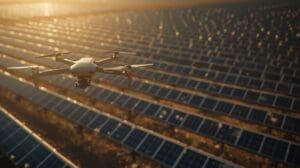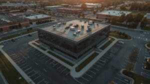
Construction crews across Raleigh are flying drones over active job sites every single week. These aren’t hobbyist gadgets. They’re commercial unmanned aerial vehicles (UAVs) equipped with thermal cameras, LiDAR sensors, and photogrammetry software that turn raw aerial data into actionable project intelligence.
General contractors, site superintendents, and project managers in the Triangle region are using drone technology to replace manual walkthroughs, catch safety violations before OSHA does, and give stakeholders real-time visual progress reports. The shift isn’t theoretical. It’s already standard practice on mid-size and large commercial builds throughout Wake County.
This guide breaks down exactly how Raleigh contractors deploy drones on job sites, what equipment and certifications they need, how much it costs, and where the technology delivers the biggest return.
Key Takeaways
- Drones replace manual site walks — A 20-acre job site that takes two hours to inspect on foot can be surveyed by drone in under 30 minutes with higher accuracy.
- FAA Part 107 certification is required — Every commercial drone operator in Raleigh must hold a Remote Pilot Certificate, and flights near RDU Airport require additional airspace authorization.
- Thermal imaging catches hidden problems — Infrared cameras on drones detect moisture intrusion, insulation gaps, and overheating electrical systems that visual inspections miss entirely.
- Costs range from $150 to $500 per flight — Most Raleigh contractors either hire a licensed drone service provider or train an in-house operator, with ROI showing within the first two months.
- Photogrammetry creates 3D site models — Overlapping aerial photos get stitched into accurate digital twins that track earthwork volumes, structural progress, and material stockpiles.
- Safety monitoring is the top use case — Drones identify fall hazards, missing guardrails, and PPE violations from above without putting inspectors in dangerous positions.
What Types of Drones Do Raleigh Contractors Actually Use?
Quick Answer: Most Raleigh contractors use quadcopter drones from DJI, specifically the Matrice 350 RTK for large commercial sites and the Mavic 3 Enterprise for residential and mid-size projects. These models support thermal, RGB, and LiDAR payloads.
The drone hardware on a construction site looks nothing like the consumer models you see at parks. Commercial construction drones carry interchangeable sensor payloads, fly pre-programmed autonomous routes, and operate in wind conditions up to 30 mph.
Quadcopters dominate the Raleigh market because they hover in place, fly slow grid patterns, and take off vertically from tight job sites. Fixed-wing drones cover more ground but need open space for launch and recovery, which most urban construction sites in downtown Raleigh or North Hills don’t have.
Popular Drone Models on Raleigh Job Sites
| Drone Model | Flight Time | Max Payload | Camera Resolution | Wind Resistance | Price Range |
|---|---|---|---|---|---|
| DJI Matrice 350 RTK | 55 minutes | 2.7 kg | Up to 61 MP (with Zenmuse P1) | 33 mph | $10,000–$13,000 |
| DJI Mavic 3 Enterprise | 45 minutes | N/A (integrated) | 20 MP wide, 12 MP thermal | 27 mph | $4,500–$5,500 |
| Autel EVO II Pro | 42 minutes | N/A (integrated) | 20 MP with 1-inch sensor | 24 mph | $1,800–$2,200 |
| Skydio X10 | 35 minutes | N/A (integrated) | 50 MP wide, 320×256 thermal | 25 mph | $10,000–$14,000 |
| DJI Matrice 30T | 41 minutes | N/A (integrated) | 48 MP wide, 640×512 thermal | 33 mph | $9,000–$11,000 |
The Skydio X10 stands out for one reason: autonomous obstacle avoidance. On cluttered job sites with cranes, scaffolding, and material stacks, the Skydio navigates itself without constant pilot input. That matters when you’re flying near a steel structure going up on Hillsborough Street.
Why Are Raleigh Contractors Choosing Drones Over Traditional Site Inspections?
Quick Answer: Drones cut site inspection time by 60% to 75%, reduce safety exposure for workers climbing structures, and produce measurable visual records that settle disputes about timeline, scope, and quality far more reliably than written notes.
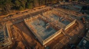
Walking a 15-acre commercial site on foot is slow. It’s also incomplete. A superintendent walking the ground floor can’t see what’s happening on the roof, behind a retaining wall, or across a 200-yard excavation. A drone at 200 feet captures everything in a single pass.
Raleigh’s construction market is competitive. Projects along the Wake County growth corridor, from downtown mixed-use developments to warehouse builds near the I-540 loop, run on tight schedules. Drone inspections let project managers check progress daily without pulling supervisors off their tasks.
Time Savings Compared to Manual Inspection
A manual walkthrough of a 10-acre site with photo documentation typically takes two to three hours. That same site, flown on a pre-programmed drone route, takes 25 to 40 minutes. The drone captures 400 to 800 geo-tagged images per flight, compared to the 30 to 50 photos a person takes walking the site.
The volume of data matters. More images mean more complete records. When a subcontractor disputes whether a footing was poured before a rain event, the drone’s timestamped, GPS-tagged photo library settles the question instantly.
Reducing Risk Exposure on Active Sites
Every time a person climbs a ladder to inspect roofing, walks along an open floor edge, or steps onto freshly graded soil near a trench, there’s exposure to falls, cave-ins, or struck-by hazards. Drones eliminate the need for many of these physical inspections. The camera goes where the person used to go.
For Raleigh contractors working on multi-story commercial builds in the Midtown or Smoky Hollow districts, this is significant. Inspecting curtain wall installations at 80 feet with a drone instead of a boom lift saves time and removes a person from an elevated work platform.
How Does Drone Photogrammetry Work on Construction Sites?
Quick Answer: Photogrammetry uses overlapping drone photos taken from multiple angles to create accurate 3D models and orthomosaic maps of a job site. Software like Pix4D or DroneDeploy processes the images into measurable digital surfaces.
Photogrammetry is the process of turning two-dimensional photographs into three-dimensional spatial data. The drone flies a grid pattern, taking photos with 70% to 80% overlap. Each photo includes GPS coordinates and altitude data. Processing software matches common points across hundreds of images and builds a 3D point cloud.
From that point cloud, contractors get orthomosaic maps (top-down, dimensionally accurate aerial images), digital elevation models (surface height data), and 3D mesh models they can rotate and measure on screen.
Photogrammetry Output Types
| Output Type | What It Shows | Construction Use Case | Accuracy Range |
|---|---|---|---|
| Orthomosaic Map | Stitched top-down aerial image | Progress documentation, site layout verification | 1–3 cm per pixel |
| Digital Elevation Model (DEM) | Terrain height at every point | Earthwork volume calculations, grading verification | 3–5 cm vertical |
| 3D Point Cloud | Millions of spatial coordinates | Structural measurement, BIM comparison | 1–2 cm with RTK |
| 3D Mesh Model | Textured 3D surface | Stakeholder presentations, visual progress reports | 2–5 cm |
| Contour Map | Elevation lines at set intervals | Drainage planning, grade verification | 5–10 cm intervals |
Earthwork Volume Tracking
One of the highest-value applications in Raleigh is earthwork measurement. Site grading contractors used to rely on GPS rovers and manual survey points to calculate cut-and-fill volumes. A drone survey captures the entire surface in one flight, producing volume calculations accurate to within 1% to 3% of traditional survey methods.
For a site-prep contractor moving 50,000 cubic yards of dirt on a project off Capital Boulevard, the difference between a 2% measurement error and a 10% estimation error translates directly into billing accuracy and material management.
What FAA Regulations Apply to Drone Use on Raleigh Job Sites?
Quick Answer: All commercial drone operations in Raleigh require FAA Part 107 certification. Flights near RDU International Airport need LAANC authorization through apps like Aloft or AirMap, and maximum altitude is capped at 400 feet above ground level.
Flying a drone for commercial purposes is federally regulated. The FAA Part 107 Remote Pilot Certificate requires passing a 60-question knowledge exam covering airspace, weather, regulations, and flight operations. The test costs $175 and the certificate is valid for two years before requiring a recurrent exam.
Raleigh-Specific Airspace Considerations
Raleigh-Durham International Airport (RDU) creates controlled airspace that covers large portions of Wake County. Job sites within five miles of RDU fall inside Class C airspace, which requires prior authorization before any drone can leave the ground.
The FAA’s LAANC (Low Altitude Authorization and Notification Capability) system automates this process. Pilots request authorization through apps like Aloft, DJI FlySafe, or AirMap. Most requests are approved within seconds if the flight stays below the designated ceiling for that grid square. Some areas near the airport have a zero-foot ceiling, meaning drone operations are prohibited entirely.
Job sites in areas like Brier Creek, Umstead, and parts of Morrisville are close enough to RDU that every flight requires LAANC approval. Sites in southeast Raleigh, Garner, or Fuquay-Varina typically sit outside controlled airspace and only need standard Part 107 compliance.
FAA Compliance Requirements Summary
| Requirement | Details | Penalty for Violation |
|---|---|---|
| Part 107 Certificate | Required for all commercial operators | Up to $32,666 per violation |
| Drone Registration | Required for all drones over 0.55 lbs | Up to $27,500 civil penalty |
| LAANC Authorization | Required in controlled airspace near RDU | Up to $32,666 per violation |
| Remote ID | All drones must broadcast identification | Civil penalties, certificate action |
| Visual Line of Sight | Pilot must see the drone at all times | Certificate suspension or revocation |
| 400-Foot AGL Ceiling | Max altitude above ground level | Up to $32,666 per violation |
Remote ID Requirements
As of 2024, all drones operating in U.S. airspace must comply with Remote ID rules. The drone must broadcast its identity, location, altitude, and control station location in real time. Most newer commercial drones have Remote ID built into their firmware. Older models may need a separate broadcast module attached to the aircraft.
How Much Does Drone Monitoring Cost for Raleigh Contractors?
Quick Answer: Raleigh contractors pay $150 to $500 per drone flight when using a third-party service, or $5,000 to $15,000 upfront to build an in-house drone program including hardware, software, and pilot certification.
Cost depends on whether you hire out or bring the capability in-house. Both models work. The right choice depends on flight frequency and project volume.
Third-Party Drone Service Pricing
Raleigh has several licensed drone service providers that specialize in construction monitoring. A standard site survey flight with orthomosaic delivery runs $200 to $400. Adding thermal imaging or LiDAR scanning pushes the price to $350 to $500 per flight. Monthly subscription packages for weekly flights typically cost $800 to $1,500 per site.
This model makes sense for contractors who need drone data on two or three active projects but don’t want to manage equipment, software licenses, or pilot training.
In-House Drone Program Costs
| Cost Component | One-Time Cost | Annual Recurring Cost |
|---|---|---|
| Drone Hardware (Mavic 3 Enterprise) | $4,500–$5,500 | $0 (replacement every 2–3 years) |
| Extra Batteries (3-pack) | $600–$900 | $300–$450 (replacements) |
| Part 107 Certification | $175 (exam fee) | $175 (recurrent every 2 years) |
| Processing Software (DroneDeploy) | $0 | $3,588–$6,588 (annual plan) |
| Insurance (hull + liability) | $0 | $500–$1,200 |
| Training (pilot proficiency) | $500–$1,500 | $0–$500 |
A fully equipped in-house program costs roughly $6,000 to $10,000 in year one. If you’re flying weekly across three or more job sites, the per-flight cost drops below $50 within six months. That’s a fraction of what third-party providers charge.
What Are the Most Common Drone Applications on Raleigh Construction Sites?
Quick Answer: Raleigh contractors use drones primarily for progress documentation, safety audits, earthwork measurement, roof inspections, thermal envelope scans, and stakeholder reporting. Each application replaces a slower, riskier, or less accurate manual process.
Progress Documentation and Timeline Tracking
Weekly or biweekly drone flights create a visual timeline of the entire project. Each flight produces a dated, GPS-referenced orthomosaic that shows exactly what was built, where materials are staged, and how the site has changed since the last flight.
Project managers overlay these maps against the construction schedule to verify that work is tracking on time. If a concrete pour was supposed to happen by Tuesday and the Thursday drone flight shows bare rebar, the schedule slip is documented automatically.
Safety Monitoring and Hazard Identification
Drones equipped with zoom cameras identify safety violations from a distance. Missing guardrails on elevated decks, workers without hard hats, unsecured material stacks, and open excavations without barricades all show up clearly in aerial footage.
Safety managers at Raleigh firms review drone footage during morning toolbox talks. Showing a crew an aerial photo of their own job site with hazards circled is more effective than a generic safety slide.
Thermal Imaging for Building Envelope Inspection
Thermal drones detect temperature differentials on building surfaces. A cold spot on a newly insulated wall indicates a gap in insulation or an air leak. A hot spot on a flat roof suggests moisture trapped beneath the membrane.
For Raleigh’s climate, where summer temperatures routinely hit the mid-90s and humidity stays high, moisture intrusion is a constant concern. Catching an envelope failure during construction costs a fraction of discovering it after the building is occupied.
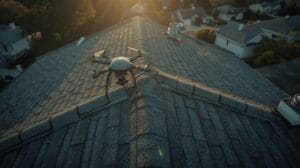
Roof and Façade Inspection
Inspecting a roof on a four-story building traditionally requires scaffolding, a boom lift, or rope access. A drone does the same job in 15 minutes. High-resolution cameras capture surface defects, flashing details, penetration seals, and drainage conditions without anyone leaving the ground.
Client and Stakeholder Reporting
Developers and investors want to see progress. A monthly drone flyover video, combined with an annotated orthomosaic map, gives stakeholders a clear picture without scheduling a site visit. Raleigh-based developers managing multiple projects across the Triangle rely on this for portfolio-level oversight.
How Do Raleigh Contractors Process and Share Drone Data?
Quick Answer: Contractors upload drone images to cloud platforms like DroneDeploy, Pix4D, or Propeller Aero. These tools process raw photos into maps, models, and measurements that the entire project team can access through a web browser.
Raw drone images are useless until they’re processed. A single flight might produce 500 to 1,000 individual photos. The processing software aligns them, corrects for lens distortion, and generates the deliverables: orthomosaics, elevation models, and 3D point clouds.
Software Platform Comparison
| Platform | Processing Speed | Storage | BIM Integration | Annual Cost |
|---|---|---|---|---|
| DroneDeploy | 2–6 hours per map | Cloud (unlimited on business plan) | Yes (Autodesk, Procore) | $3,588–$6,588 |
| Pix4D | 3–8 hours per map | Local or cloud | Yes (BIM export) | $3,990 (perpetual license) |
| Propeller Aero | 4–12 hours per map | Cloud (unlimited) | Yes (Autodesk, Trimble) | Custom pricing |
| OpenDroneMap | Varies (local processing) | Local only | Limited | Free (open source) |
Integrating Drone Data with Project Management Tools
The real value shows up when drone data connects to the tools contractors already use. DroneDeploy integrates directly with Procore, the project management platform used by many Raleigh general contractors. Orthomosaic maps, measurement annotations, and progress photos flow into Procore’s daily log and photo library automatically.
This integration means the superintendent doesn’t manage two separate systems. Drone data lives alongside RFIs, submittals, and schedule updates in one place.
What Challenges Do Raleigh Contractors Face With Drone Operations?
Quick Answer: The biggest challenges include airspace restrictions near RDU Airport, weather disruptions from rain and high winds, data management bottlenecks with large image files, and the learning curve for integrating drone workflows into existing project management processes.
Weather Limitations in the Triangle
Raleigh’s weather creates real constraints. Summer thunderstorms can ground drones for days at a time. Wind gusts during spring storm season exceed the safe operating limits for most commercial UAVs. Winter brings shorter daylight hours, which limits the number of flights per day under Part 107’s daylight operations rule.
Smart operators build weather buffers into their flight schedules. If the project needs weekly surveys, they schedule backup flight windows on alternate days.
Data Storage and Processing Bottlenecks
A single drone survey generates 10 to 30 GB of raw image data. Over the life of a 12-month project with weekly flights, that’s 500 GB to 1.5 TB of aerial imagery per site. Cloud storage handles the volume, but upload speeds and processing times create delays.
Contractors with multiple active sites can hit storage limits or bandwidth constraints quickly. Planning for data infrastructure is just as important as planning the flight itself.
Crew Adoption and Workflow Integration
Technology only works if people use it. Some field teams resist changing their inspection routines. The fix is simple: show results. When a superintendent sees a drone catch a grading error that would have cost $40,000 to fix after concrete placement, the value becomes obvious.
What Does the Future of Drone Monitoring Look Like for Raleigh’s Construction Industry?
Quick Answer: Autonomous drone docking stations, AI-powered defect detection, and real-time digital twin integration will transform how Raleigh contractors monitor job sites within the next three to five years, reducing the need for manual flight operations entirely.
Autonomous Dock-and-Fly Systems
Companies like DJI and Skydio now sell drone-in-a-box systems. The drone lives in a weatherproof docking station on the job site. It launches on a pre-set schedule, flies its route, lands, and uploads data without any human involvement. The pilot monitors remotely from an office or trailer.
For large Raleigh projects running 18 to 24 months, a permanent docking station eliminates the need to send a pilot to the site every week. The drone flies itself at 7 AM every Monday, and the processed data is in the project manager’s inbox by noon.
AI-Powered Image Analysis
Machine learning models are getting trained to detect construction defects, safety violations, and progress deviations automatically. Instead of a person reviewing 800 photos from a single flight, software flags the images that show potential problems: a crack in a foundation wall, a missing anchor bolt, or a worker in a restricted zone.
This is already in beta on platforms like DroneDeploy and Buildots. Within a few years, the drone-to-alert pipeline will be fully automated.
Real-Time Digital Twin Updates
A digital twin is a live 3D model of a building that updates as construction progresses. Drone data is the fastest way to feed that model. Each flight adds a new layer of as-built reality to the digital twin, letting designers and engineers compare what was planned (the BIM model) against what was actually built.
Raleigh firms working on complex mixed-use projects in the Warehouse District and along Glenwood South are early adopters of this approach.
Frequently Asked Questions
Do You Need a License to Fly a Drone on a Construction Site in Raleigh?
Yes. Any commercial drone operation requires an FAA Part 107 Remote Pilot Certificate. The exam costs $175 and covers airspace rules, weather, and safe flight operations. Flying commercially without this certificate carries civil penalties up to $32,666 per violation.
Can Drones Fly in Controlled Airspace Near RDU Airport?
They can, but only with prior authorization through the LAANC system. Pilots request approval through apps like Aloft or AirMap before every flight. Some grid squares near the airport have altitude ceilings as low as zero feet, which means no drone operations are permitted in those areas.
How Accurate Are Drone Surveys Compared to Traditional Land Surveys?
Drone surveys using RTK (Real-Time Kinematic) GPS achieve horizontal accuracy of 1 to 2 centimeters and vertical accuracy of 3 to 5 centimeters. Traditional land surveys are slightly more precise at the individual point level, but drones capture millions of data points per flight, giving a more complete picture of the entire site surface.
What Happens to Drone Data After the Project Is Finished?
Most contractors archive drone data on cloud platforms for the duration of the project warranty period, typically one to two years. Some owners require permanent archival for facility management purposes. The timestamped, GPS-referenced images serve as legal documentation of construction conditions at every stage.
Can Drones Operate in Rain or High Winds?
Most commercial construction drones are not rated for rain. Water damages motors, electronics, and camera lenses. Wind limits vary by model, but most quadcopters can handle sustained winds up to 25 mph. Gusts above 30 mph typically ground all operations. Operators check weather conditions before every scheduled flight.
How Long Does It Take to Get Usable Data After a Drone Flight?
Processing time depends on the number of images and the software platform. A standard orthomosaic from 500 images takes two to six hours on cloud platforms like DroneDeploy. Complex 3D models with LiDAR data can take 12 to 24 hours. Most contractors have next-day turnaround for standard progress documentation deliverables.